Prepared for: Montana Department FW&P
Prepared by: Weed Management Services
The purpose of this report is:
- to summarize historical information regarding management of leafy spurge on the Smith River
- discuss management activities conducted in 1996
- outline management options and strategies for noxious weeds within and adjacent to the Smith River corridor
I. HISTORICAL INFORMATION: 1975 THROUGH 1995
Data for this summary were collected from Meagher County Weed District, USFS Kings Hill Ranger District, Cascade County Weed District, MT Dept. of Fish Wildlife and Parks, private landowners, and Bureau of Land Management. Information was divided into categories regarding weed inventories, chemical, cultural, and biological control efforts.
A. WEED INVENTORIES:
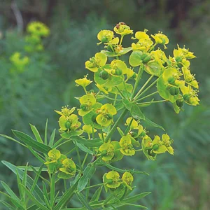
Leafy spurge is believed to have been introduced into the Smith River area during late 1920's to 1930's on private land along Tenderfoot Creek. By the 1950's, Anderson's (private landowners bordering the Smith River, downstream from Tenderfoot Creek) recognized the weed as a problem within the river corridor. Anderson's used 2, 4-D in the 50's and early 60's to treat and contain infestations. They observed that the flood on the river in the early 60's greatly accelerated the spread of the weed.
A cooperative weed inventory project was initiated on the Smith River between Cascade County Weed District and the USFS. The inventory encompassed the portion of the river from its confluence with the Missouri to Tenderfoot Creek. ECON Consulting of Helena, MT was hired to conduct the aerial inventory using true color and IR (infra-red) color aerial photographs at 1:24,000 scale. Areas infested by leafy spurge were determined using color signature on aerial photos. Infestations recorded on maps were then correlated with field observations. As part of this project, permanent monitoring points were established at 8 locations along the Smith River to determine effectiveness of various treatments. Results of monitoring are discussed within the herbicide section.
The inventory indicated that approximately 90% of leafy spurge was detected by color IR. Most infestations were less than 1 acre in size, with the largest infestation located at the mouth of Tenderfoot Creek. Infestations occurring within steep canyons, under dense tree canopy, and those receiving herbicide treatments may not have been recorded due to loss of photo recognition. Leafy spurge infested acreage from Tenderfoot Creek to Eden Bridge totaled 208 acres in 1977. Original reports and photographs are available with Cascade County Weed District.
The USFS conducted an inventory of leafy spurge on a portion of forest land adjacent to the Smith River in 1986. Although acreage of some infestations was recorded, other areas of leafy spurge were delineated as a dot. Acreage estimates for "dots" were not available. Original maps are on file with the USFS, White Sulphur Springs. In addition to this inventory data, Meagher County Weed District updated the location and size of infestations on Elk Canyon Ranch and Dawson property (mouth of Tenderfoot Creek) in 1995.
Inventory data from 1977, 1986, and 1995 were combined and placed on topographic maps (1:24,000 scale). Acreage estimates were determined using a dot grid. Total acreage infested with leafy spurge from Eagle Creek downstream to Eden Bridge was 673 acres. Infested acres from Tenderfoot Creek downstream to Eden Bridge in the initial IR survey (1977) were compared to maps which included 1986 and 1995 data. Infested acres increased over this section of river from 215 acres in 1977 to 639 acres.
B. CHEMICAL CONTROL:
An active chemical control program on leafy spurge was initiated on the Smith River in 1978. Cascade County was responsible for the majority of chemical work along the river corridor from 1978 through 1985. This included work for private landowners in addition to USFS. Herbicides included Banvel + 2, 4-D, Tordon 2K pellets, and Tordon 22K liquid. Helicopters were used to transport applicators to remote sites on the river. In addition, vehicles were driven up the Tenderfoot during low water to access leafy spurge along the river. Contracts in 1985 with the USFS indicated that 62 acres of leafy spurge were treated on forest lands adjacent to the Smith River and the mouth of Tenderfoot Creek for a cost of $4375.00.
A limited herbicide program for control of leafy spurge along the river continued through 1987 on USFS lands. Records indicate that 5.79 acres and 5.0 acres of leafy spurge were treated on the Smith River and Tenderfoot Creek respectively in 1987 by the USFS.
Results of the chemical effort were monitored with 8 permanent transects located along the Smith River. Data were collected in 1977 prior to herbicide applications and again in 1983 following 5 years of herbicide treatments. There were no permanent transects located in areas that were not treated. Results of the chemical program are shown in Table 1.
There has been no consistent herbicide management program for leafy spurge on the Smith River since 1985. Limited acres were treated in the Tenderfoot Creek area by the USFS through 1987. In addition, Meagher County Weed District annually treats a small site that serves as a “weed free” parking area for vehicles in the Tenderfoot area.
Herbicides are used to manage weed infestations at Eden Bridge as part of the lease agreement with the landowner.
C. BIOLOGICAL CONTROL:
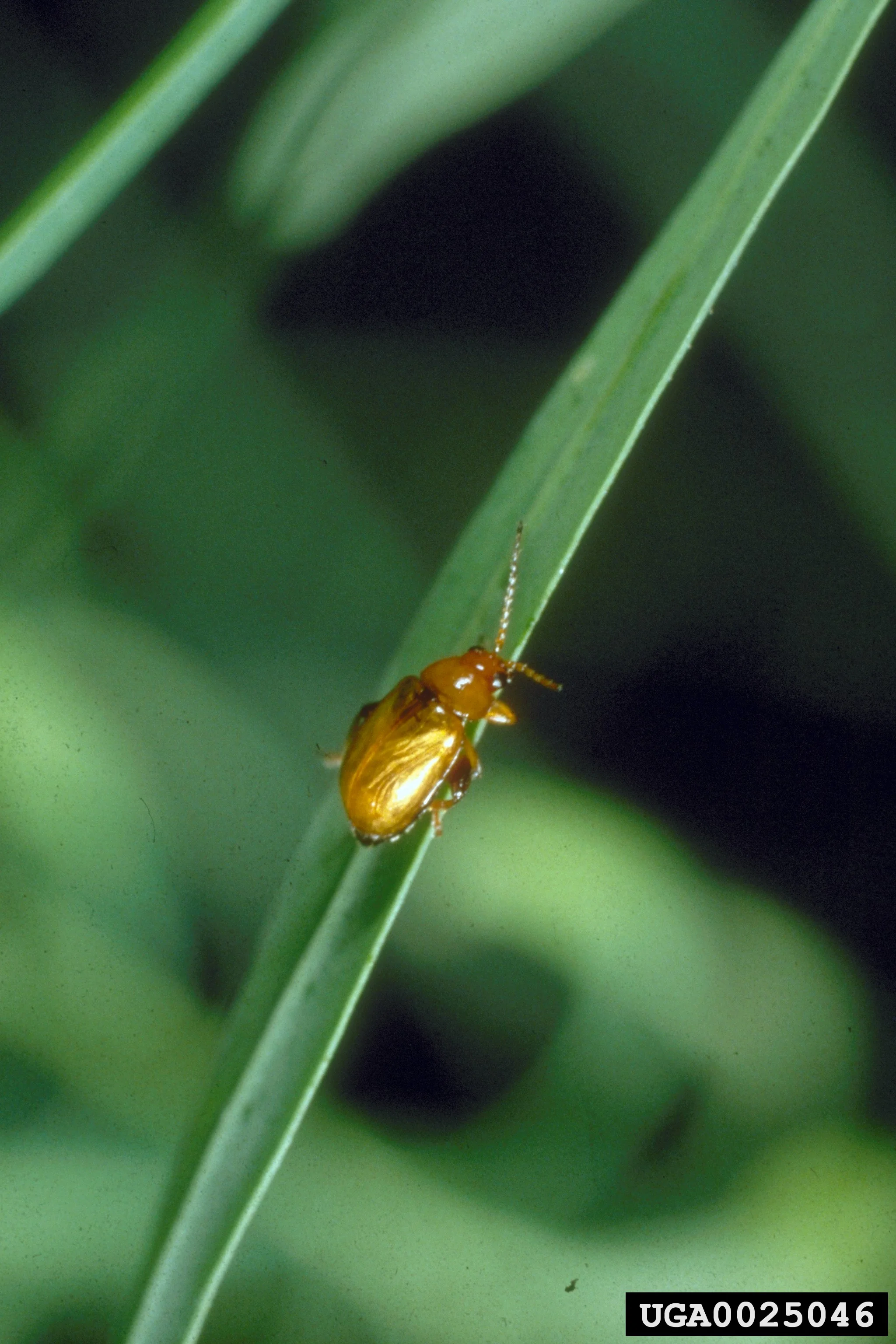
Biological control of leafy spurge on the Smith River began with a 1991 grant from MT Dept. of Agriculture, Noxious Weed Trust Fund to Meager County Weed District. The grant funded the purchase and release 2250 Aphthona nigriscutis and 2250 Aphthona flava on the Smith River. Objectives of the project were to release insects at key locations, identify and photograph release sites, and monitor establishment and success of the insects. In addition to insects released by Meagher County, the USFS also released 1500+ Aphthona nigriscutis on forest lands along the Smith River in 1991. Photographs and field
Table 1: Change in leafy spurge cover and frequency from 1977 to 1983 on the Smith River.

Notes from this initial project are on file with Meagher County Weed District. Appendix I indicates the number, type, and location of insect releases from 1991 through 1995.
Various insect agents were released on 65 different sites on the Smith River from 1991 through 1995. Agencies responsible for releases include Meagher County Weed District, Cascade County Weed District, USFS, FW&P, and BLM. Total number of insects included: 21,450 Aphthona nigriscutis, 3250 Aphthona flava, 250 Aphthona cyparissiae, 250 Aphthona lacertosa, 80 Aphthona czwalinae, and 1 bundle of Spurgia esulae. Approximately 30 percent of the insects have been released on Dawson property near the mouth of Tenderfoot Creek. Two sites of Aphthona nigriscutis, MC11-91 and MC4-94, located near Tenderfoot Creek (Dawson Property) are know to be established. Site MC11-91 has been used since 1993 to collect and redistribute insects along the Smith River. In addition, a small number of Aphthona flava were found in 1994 near Tenderfoot Creek, site number MC20-91. There has been no other recorded establishment of insects at any other sites.
Monitoring establishment of insect populations has been erratic because of inaccurate or vague descriptions of original release sites, and difficult access to many sites. Efforts were made in 1993 by Richard Fairweather, Meagher County Weed District, to locate and record the status of releases from the upper portions of the Smith River to Tenderfoot Creek. Photographs were taken of 10 of 18 sites that were positively located, and are on file with Meagher County Weed District. In addition to Meagher County efforts, a USFS site along Tenderfoot Creek (USFS1-91) was reviewed in 1992 and no establishment of the insect recorded. The Tenderfoot Creek area has been monitored annually since 1993.
Recorded information regarding status of insect releases for leafy spurge control on the Smith River is estimated to account for about 90% of the agents that have been released. The hawk moth, Hyles euphorbiae, was observed in 1991 near Tenderfoot Creek (USFS1-91). However, no record of its release was found in either county weed district or agency offices. In addition, a naturally occurring rust on leafy spurge has been moved to several locations along the River, but sites not recorded.
D. CULTURAL CONTROL:
Sheep have been utilized on the lower portions of the Smith River on McKamey Ranch to manage infestations of leafy spurge. Predators and other management problems associated with sheep have limited their use on most of the river corridor.
Weeds have been controlled at Camp Baker by hand pulling since 1992. Weed information was placed at Camp Baker to encourage floaters to identify and report weeds.
E. SUMMARY
Leafy spurge management along the Smith River corridor has been sporadic during the past 20 years. There was an active inventory and chemical control program from 1977 through 1985. However, environmental constraints, reduced budgets, and difficult access along much of the river have made management with herbicides extremely difficult. The availability of biological control agents has enhanced management options for leafy spurge since 1991. Most insects available for release have been placed in the area, although numbers of some species are relatively low. Status of many release sites is unknown because of difficulty of access and vague descriptions of sites.
There is little information regarding noxious weeds infestations and control efforts available for lands within a 1 to 2 mile border of the Smith River. This information is critical for developing management strategies for weeds within the river corridor.
II. WEED MANAGEMENT ACTIVITIES - 1996
A cooperative meeting was organized in spring of 1996 that included Fish Wildlife and Parks, USFS, and Cascade and Meagher County Weed Districts. The purpose of the meeting was to develop strategies for weed management along the Smith River corridor. A trip was organized in late June, 1996 to review and map weed populations along the Smith River, and develop long-term weed management goals. Participants on the float trip included Tim Bond, Jim Olivarez, and George Markim with USFS, Doug Habermann and Tom Sabol with FW&P, and Celestine Duncan, consultant. The following activities were accomplished on the float.
A. WEED INVENTORY:
Leafy spurge infestations were inventoried the last week of June on the Smith River from Camp Baker to Eden Bridge. Infestations along the river were identified from the ground and an aircraft was used to detect infestations on open grassland sites above the corridor. Topographic maps at 1:24,000 scale were utilized to record infestations.
Inventory data were entered into ARC-INFO GIS data base by Montana State University in a format compatible with both FW&P and USFS systems. FW&P correlated infestation information with existing data bases of the river and land ownership. Total acreage infested with leafy spurge from Camp Baker to Eden Bridge was 1551. This accounted for a 230% increase in acres from previous inventories. Infestations by land ownership are shown in Table 2 and maps of data are in Appendix II.
Table 2: Leafy spurge Acreage by Land Ownership.

Based on 1996 field inventory. See 1996 Weed Survey Map
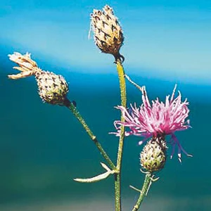
Musk thistle was the only other noxious weed observed within the river corridor. Infestations are very small, and confined to isolated sites on the canyon slopes. Because of the small number of infestations, and presence of the bio-control agent Rhinocyllus conicus, these infestations were not included in the GIS data base. USFS has reported spotted knapweed infestations up Tenderfoot Creek, however, the weed was not observed along the Smith River.
B. BIOLOGICAL CONTROL:
Selected sites where insect releases had been made in previous years were sampled to determine if insects had established. Status of sites is shown in Appendix I. There was some concern by George Markin that we may have been too early to monitor sites. He suggested monitoring sites at least one week later in 1997.
USFS, Montana Dept. of Agriculture, and Cascade County Weed District, and site MC11-91 (Tenderfoot Creek) provided insects for additional releases following the river float in June, 1996. A total of fifty-one releases were made in 1996. These included 30,250 Aphthona nigriscutis, 9 bundles of Spurgia esula, and 6200 Aphthona lacertosa/czwalinae. Insects were released by Doug Habermann, FW&P, and Tim Bond, USFS. Release sites for 1996 are shown in Appendix I.
Site data were collected from FW&P and USFS, located on topographic maps, and summarized in a spread sheet. Data were sent to MSU to be digitized into GIS. The data base will be compatible with both FW&P and USFS systems.
III. MANAGEMENT OPTIONS AND STRATEGIES:
General Observations:
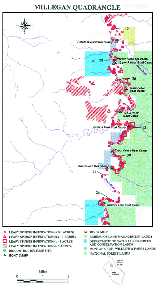
Leafy spurge is established the entire length of the Smith River from Camp Baker to Eden Bridge. Most infestations upstream from Tenderfoot Creek that are not being managed by private land owners range in size from several plants to less than 0.10 acre. Infestations below Tenderfoot Creek are large and occupy most river banks, terraces, and open foothill slopes. Leafy spurge infestations outside the river corridor include areas on Songster Butte, Spring Creek, Tenderfoot Creek, and private lands west of the river on Millegan Quadrangle. There were no other noxious weed species located within the river corridor.
Management options for leafy spurge on the Smith River will be divided into three areas: (1) Camp Baker to Tenderfoot Creek; (2) Tenderfoot Creek to Eden Bridge; and (3) Outside the River Corridor. Leafy spurge acres were manually calculated for these management areas and total 1513 acres rather than 1551 acres by GIS.
A. Camp Baker to Tenderfoot Creek
Leafy spurge infests about 57 acres along this section of the river. The majority of infestations (88%) occur adjacent to the river and range in size from 6 acres to several plants. Most infestations greater than 1 acre are currently being managed by private landowners. Biological control with insects is not a feasible alternative for this section of the river due to low spurge density and difficulty in establishing insects on sites with seasonal flooding.
Isolated infestations of leafy spurge are located on Ray Creek, Spring Creek, Songster Butte, and on the west side of the river. Infestations comprise about 7 acres, or 12% of the total. These sites should receive a high priority to keep leafy spurge from spreading into uninfested uplands. Management options for small, scattered infestations include physical and/or chemical methods.
1. Physical Methods:
a. Hand pulling: This method will control seed production and may eliminate young seedling plants, but will not stop lateral spread of leafy spurge roots. Plants must be pulled prior to seed ripening (mid to late June). Pulling may be necessary every three to four weeks from mid-June through the remainder of the growing season to stop seed production.
b. Mowing: Mowing will reduce seed production if repeated every three to four weeks during the growing season. It will not provide long-term control of the plant or stop lateral spread by roots.
2. Chemical Methods:
Herbicide treatments will provide more long-term control of leafy spurge than either hand removal or mowing. Newly established infestations should be treated as soon as possible to prevent seed production and spread of the weed. Treat an extra 15 feet around patches to control spreading roots and seedlings.
Herbicide treatments within 10 feet of water and on shallow groundwater sites:
2, 4-D formulations labeled for use near water: Apply at 1 qt/ac at true flower stage (mid/late June); will stop seed production; annual applications necessary.
Krenite S @ 1.5 to 2 gallons/acre: apply at true flower stage; control best oncoarse textured soils; control may be inconsistent on some sites.
Rodeo @ 1.5 to 2 pints/acre: apply from mid-July to mid-September (seed dispersalstage) for best results apply with a non-ionic surfactant approved for use near aquatic sites. This treatment is non-selective to other vegetation, and is most suited to gravel sites with little grass cover.
Plateau (AC263, 222): This is a new herbicide that is showing promise for leafy spurge control on sensitive sites. Applications of 2 oz ai/ac applied in the fall have provided up to 80% control one year after treatment. There is little information available regarding effect of this herbicide on cool season desirable forages growing within leafy spurge infestations. Research results should be available in 1997 that will address this issue. Greatest control is achieved when the herbicide is applied in the fall.
Herbicide treatments above 10 feet of the river.
Tordon @ 1 qt/ac: Most effective herbicide for control of leafy spurge. Apply at true flower growth stage (mid June). Follow-up treatments with Tordon @ 1pt/acre + 2, 4-D @ 1 qt/ac for three consecutive years.
Sites where access is difficult: Apply Tordon @ 2 qt/ac with a follow-up treatment the next year with Tordon @ 1 qt/ac.
Plateau (AC263, 222): Based on 1997 research results, this herbicide may be on option for control. Apply at 2 oz ai/ac in the fall followed by 2 oz ai/ac in the spring.
3. Special Management Areas:
Management Options for Leafy Spurge within DFWP Boat Camps:
1. Upper and Lower Spring Creek BC: No noxious weeds present on site
2. In-lieu: Approximately 0.15 acre infested with leafy spurge. Recommendation -treat with Tordon @ 1 qt/acre up to 10 ft from the river and Krenite S @ 2 gal/ac to within 10 feet of the river; possible option of Plateau herbicide application.
3. Indian Springs BC: Small infestations of leafy spurge - treat as described for In-lieu BC based on site conditions.
4. Rock Garden BC: No spurge noted within boat camp. Small infestations adjacent to river near boat camp should be treated with herbicides as described for In-Lieu BC.
5. Mouth of Rock Creek BC: Several small infestations of leafy spurge near water. Treat with either Rodeo or Krenite based on site conditions.
6. Scotty Allans Black Canyon BC: no infestations noted directly in camp.
7. Dry Canyon BC: no infestations noted directly in camp.
8. Tenderfoot Creek to Eden Bridge:
Leafy spurge occupies 956 acres within the river corridor from the north side of Tenderfoot Creek to Eden Bridge. Infestations range in size from several plants to 50+ acres. Above and west of the river corridor, leafy spurge infests about 500acres of private land (Milligan Quad). In addition, small satellite infestations of leafy spurge were observed near the upper portions of the canyon walls. It is critical to contain infestations to the river corridor where possible.
1. Special Management Areas:
a. Tenderfoot Creek - Private Land:
Private property adjacent to Tenderfoot Creek has dense infestations of leafy spurge totaling about 130 acres. Options for this area include a combination of physical, biological, and chemical treatments depending on resources available for spurge management.
1. River bench south of Tenderfoot Creek: Leafy spurge infestations presently occur as small to medium size “patches” and should be treated with herbicides or herbicides plus biological control agents, to prevent movement into uninfested sites. If herbicides are used alone, apply Tordon @ 2 qts/ac in June with a follow-up treatment the following year of Tordon @ 1 quart/ ac. Herbicides plus biological control agents should include a fall application of Tordon 22K at 1 quart/acre applied in the fall of the year in combination with Aphthona nigriscutis (or similar agent). These treatment should contain and reduce the size of infestations and prevent movement into upland sites.
2. Previously cultivated land north of Tenderfoot Creek: Leafy spurge occurs as a solid infestation on about 130 acres. Management options for this area could include an integrated program that utilized herbicide treatments and reseeding with competitive grass species; continued release of biological control agents; and sheep grazing. Herbicide treatments on the perimeter of the infestations should be directed toward slowing the spread into uninfested sites to the south and east.
Herbicide/Reseeding Program: Research conducted at Univ. of Wyoming and North Dakota State indicate that Roundup applied at the rate of 1qt/acre in June, followed by a second application in July, followed by tillage and seeding to select grass species in mid August, provided excellent control of leafy spurge for up to 4 years following treatment. Control appears to be declining after 4 years and either fertilization, herbicide treatments, or biological control agents should be incorporated in the management program to maintain control (Lym, pers. comm). Difficulty in accessing the area with equipment, and relatively high initial costs may reduce feasibility of reseeding.
Sheep grazing: Sheep will utilize leafy spurge and keep the plant from producing seed. Herbicide applications along the perimeter of the infestation would be necessary to prevent lateral spread of the plant. Cost effectiveness of utilizing sheep has been proven in other locations; however, its feasibility may be limited because of predator problems.
Aphthona nigriscutis is well established on this site and a reduction in leafy spurge density is evident. In addition, a rust was located on leafy spurge growing on the south facing slope east of the homestead buildings. Biological control should remain an integral part of any management program selected for this site.
b. Boat Camps from Tenderfoot Creek to Eden Bridge
Boat camps located downstream from Tenderfoot Creek have moderate to severe infestations of leafy spurge. These sites serve as a source of contamination to other areas as leafy spurge seed will become trapped in recreational equipment and moved from the site. Although seed production could be stopped on these sites by annual herbicide applications or mowing, the cost would be extremely high. In addition, leafy spurge infests most of the river banks between boat camps, thus opportunity to transport spurge propogules downstream remains certain even if the boat camps are treated. Releases of biological control agents is a high priority within most camps to reduce seed production. Aphthona nigriscutis, A. lacertosa, A. flava, Obera erythrocephala* and other insects as they become available should be established on all camps. Limited herbicide applications on leafy spurge infestations at several camps should help reduce spread of the weed.
1. Canyon Depth BC: Release biological control agents & monitor establishment.
2. Two Creek BC: Establishment of A. nigriscutis documented in 1996. Additional releases of APNI made in 1996. Potential for limited treatment of small satellite infestations with Tordon 22K at 1 qt/acre to prevent leafy spurge movement into timbered areas and steep slopes.
3. Sheep Wagon BC: Release of APNI by USFS in 1991; no record of establishment. Release additional biological control agents & monitor establishment.
4. Cow Coulee BC: Release biological control agents & monitor establishment.
5. Sunset Cliff BC: Release biological control agents & monitor establishment.
6. County Line BC: Release of APNI by FWP in 1995; no record of establishment. Release additional biological control agents & monitor establishment. One small satellite infestation of leafy spurge on southwest facing slope that could be treated with Tordon 22K at 1 qt/ac to prevent movement into non-infested sites.
* Note: Obera should be released on leafy spurge with "pencil-size" diameter stems (Spencer, pers. comm.)
7. Bear Gulch BC: Releases of APNI by USFS in 1991 and FWP in 95; no record of establishment. Release additional biological control agents & monitor establishment. This site is adjacent to G. Andersons who are actively managing leafy spurge. A limited herbicide program within Tordon 22K at 1 qt/ac or Krenite (depending on site conditions) to maintain a buffer along the fence line and a weed free corridor along the access road would support Andersons control efforts.
8. Trout Creek BC: Release biological control agents & monitor establishment.
9. Crows Foot BC: Release biological control agents & monitor establishment.
10. Table Rock BC: USFS APNI release in 1991; no record of establishment. Release additional biological control agents & monitor establishment.
11. Fraunhofer BC: Release biological control agents & monitor establishment. Small satellite infestations of leafy spurge on southwest facing slope (NE of boat camp) that could be treated with Tordon 22K at 1 qt/ac to prevent movement into non-infested sites.
12. Upper Parker Flat BC: USFS release of APNI in 1991; no record of establishment. Release additional biological control agents & monitor establishment.
13. Parker Flat BC: Release biological control agents & monitor establishment.
14. Paradise Bend BC: BLM release of APLA in 1995, no record of establishment. Release additional biological control agents & monitor establishment. Small satellite infestations of leafy spurge on west facing slope (N of boat camp) that could be treated with Tordon 22K at 1 qt/ac to prevent movement into non-infested sites.
15. Staigmiller BC: Release biological control agents & monitor establishment.
16. Merganser Bend BC: Leafy spurge not present within camp sites but adjacent to takeout. Release biological control agents & monitor establishment.
17. Ridge Top BC: Release biological control agents & monitor establishment.
18. Black Butte BC: Limited spurge adjacent to river.
19. Givens Gulch BC: APNI release in 1995, establishment documented in 1996. Monitor site and establish other insect species.
20. Rattlesnake BC: APNI released in 1995, no establishment recorded in 1996. New release of APLA in 1996 on southwest facing hill slope. Release additional biological control agents & monitor establishment.
c. Infestations Above the River Corridor
The largest spurge infestations located outside the river corridor occupy about 500 acres of private land. In addition to large infestations, satellite patches were recorded on the map. Containment of large infestations and control of small satellite infestations is critical to maintain and reduce leafy spurge acreage. An integrated approach utilizing grazing animals, biological control agents, and herbicides should be utilized. Private land owners adjacent to the river corridor should be an integral part of the noxious weed management strategy for the Smith River corridor.
IV: SUMMARY
Leafy spurge is well established throughout the Smith River corridor. There were no other noxious weed species of significant concern located along the river during the inventory in June, 1996. Most infestations of leafy spurge located above Tenderfoot Creek can be contained or eradicated with a consistent herbicide program. The following areas are priorities for management of leafy spurge on lands within and adjacent to the Smith River corridor:
Initiate a prevention strategy to maintain the area free of other noxious weeds listed on the state noxious weed list. Annual or biannual inventories should be conducted along the river with the specific objective to monitor for noxious weed invasion. High recreational use makes this area susceptible to invasion.
Organize a management team comprised of county, federal, state, and private individuals to develop goals and objectives for weed management along the Smith River.
Contain leafy spurge within the river corridor by initiating containment and control programs on leafy spurge infestations adjacent to the corridor.
Control and eradicate leafy spurge where possible along the river and tributaries between Camp Baker and Tenderfoot Creek.
Expand release of biological control agents. County weed districts should be involved with all release of bio-agents; additional contacts include USFS, APHIS, ARS, UM, and MSU.
Inventories should be conducted on uplands adjacent to the river corridor and on stream tributaries flowing into the Smith River to determine the extent of leafy spurge infestations. This information is vital to maintaining containment and control programs within the river corridor, and will ultimately affect the success of the program.
Develop educational and awareness brochures, displays, etc. on noxious weeds for recreational users.
Consider development of a Noxious Weed Trust Fund grant request to assist private landowners and federal agencies in implementing control programs, and/or conducting weed inventories.
Smith River 1997 Weed Activity Summary
DFWP continued participation in the Smith River Coordinated Weed Group (SRCWG) and implementation of the Smith River Weed Report and Region Four Weed Management Plan.
DFWP participated in a 4-day bio-control float during which most former release sites were checked for success and 23 additional releases were made at new sites. Five different agents were released including flea beetles, Oberea and Spurgia. In many cases, bugs from established sites were moved a short distance to increase the rate of spread.
DFWP cooperated in funding a 4-day chemical control float, the first on-river chemical control since 1987. Five point seven acres of DFWP lands were treated and ten acres of Federal land were treated. A display on SRCWG efforts was assembled and presented at the Montana Weed Control Association's annual meeting.
Doug made good contact with Greg Carlson, a landowner with a major Spurge problem. He welcomes bio-releases, monitoring, etc. on his place. We will need to develop a site plan for his property. The team worked together to revise the floater's packet to include a Leafy Spurge/ Noxious Weed insert to inform floaters and to request that out of area floaters wash vehicles and equipment before coming to the river.
The SRCWG held two informational meetings in White Sulphur Springs and at the Eden Community Hall. Attendance was light but letters and copies of the Smith River Weed Report were sent to all landowners.
Two workshops for area landowners were held on July 12 and 19 including information on weed control, specific species control strategies, what the SRCWG is trying to accomplish and handing out of Spurge control agents. Barbara Mullen, Montana Department of Agriculture and Roger Sheeley, Montana State University presented information at the workshops. Ten landowners attended the upper river workshop and twenty-five the canyon workshop. The complete range of Smith River landowners from cabin site owners to large ranch managers was represented. Good events!
An update was sent to canyon landowners who responded to the initial letter or came to the initial meetings.